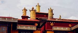
Tashilhunpo Monastery is the residence of the Panchen Lama and the largest monastery in the southern Tibetan region. It houses the largest Buddha exhibition platform in Tibet. Every year, around the 15th day of the fifth month of the Tibetan calendar, Tashilhunpo Monastery displays huge thangkas depicting past, present, and future Buddhas, which is quite spectacular.
Sangzhu Zongbao
The Sangzhuzi Fortress in Shigatse, Tibet is located on the west side of the city. It takes about 1.5 hours to drive along Provincial Road 204 to reach there. This building is now the Shigatse Museum and is also known as the "Little Potala Palace" due to its typical Tibetan castle style.
Yarlung Zangbo River
Crossing over the Yarlung Tsangpo River, which is the highest elevation river in the world, the area belongs to the middle reaches of the Yarlung Tsangpo River basin. The river is wide and flat, and the terrain is mainly river valley plains. In the agricultural areas of Tibet, the focus is mainly on the Yarlung Tsangpo River basin. West of Lazi County, the section of the Yarlung Tsangpo River is commonly referred to as Dazhuoka Bu, meaning "the water flowing from the mouth of a good horse."
Mount Everest Base Camp
There are two base camps set up in China for observing the core zone of Mount Everest's environment. The West Base Camp is located in Zaxi Zongxiang, Dingri County, Xigaze, Tibet Autonomous Region, with an altitude of 5,200 meters and a distance of approximately 19 kilometers from the summit of Everest. The East Base Camp is situated in Gama Valley, Qudang Township, Dingri County, also at an altitude of 5,200 meters. Nepal also has its own base camp.
Lake Manasarovar
About 7 hours and 30 minutes drive along G219 to reach Baga, then turn into G564, the left side of the road is Lake Mapam Yumco. This "unconquered emerald lake" is one of the three sacred lakes of Tibetan Buddhism and a holy site for Hinduism. The lake has extremely high transparency, and the water and grass are abundant.
Liangcuo
"The Ghost Lake" La'ang Co and Mapam Yumco are separated by only one road, but their sceneries are completely different. There is almost no vegetation by the lakeside, and the water is not drinkable for humans and animals. When the weather is clear, you can directly overlook the towering pyramid-shaped peak of Mount Kailash from La'ang Co.
Mount Kailash
Mount Kailash is the main peak of the Gangdise Mountains, with an elevation of 6,656 meters. It is considered a sacred site by multiple religions and is therefore known as the "King of Sacred Mountains." The summit of the sacred mountain is often hidden in clouds and mist, and it is said that those who are fortunate enough to see it will receive good luck.