Singwe Wildlife National Park
Þingvellir is one of Iceland's most famous historical sites, where the Icelandic parliament or Althing was established in the year 930 AD, and it continued to convene there for almost nine centuries until 1798. Many events from the Saga of Icelanders also took place here. In 1930, it was designated as a national park. In 2004, Þingvellir was added to the UNESCO World Heritage List. Located on the northern shore of Iceland's largest lake, Þingvallavatn, Öxará River runs through the national park, forming a waterfall at Almannagjá called Öxaráfoss, along with the ancient waterfall of Gullfoss and the geysers of Haukadalur, Þingvellir is a part of Iceland's most famous tourist route, the Golden Circle.
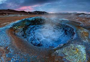
Geyser thermal area
The Great Geysir in Iceland's Golden Circle route is one of Iceland's most famous natural attractions, but it has been dormant since it stopped erupting in 1916, with only one revival in 1935. Now, the highlight of the area is another geyser 100 meters south of the Great Geysir called Strokkur (The Churn). This area is a geothermal park, situated on top of a huge boiling cauldron, spewing out strange-colored sulfur mud pots, hissing steam vents, hot and cold springs, warm streams, and primitive plants, attracting many tourists. The Strokkur geyser erupts approximately every 10 minutes, with a spectacular white boiling water column reaching up to 30 meters high.
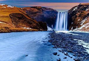
Golden Waterfall
The Golden Waterfall in southern Iceland is a combination of two waterfalls, with a drop of 11 meters for the upper waterfall and 21 meters for the lower one. The riverbed at the bottom of the Golden Waterfall is made up of rocks from the previous ice age. On average, 109 cubic meters of water flow through the waterfall per second, with a record high of 2000 cubic meters per second during floods. In the summer, the flow is 130 cubic meters per second, enough to fill an entire building in just 3 seconds. There have been various proposals to increase its energy development potential, including hydroelectric development on the Hvítá River. Now, the trail to the Golden Waterfall may be closed, so it's best to check the Safetravel.is website before heading there to see if the waterfall is open to visitors.
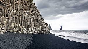
Reynisfjara black sand beach
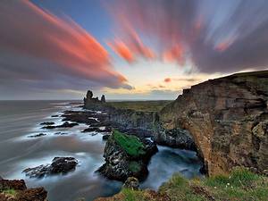
Reynisfjall is a 340-meter-high tuff mountain near the village of Vik, originating from volcanic eruptions during the penultimate glacial period. It alternates between tuff layers, pillow lava layers, and columnar basalt veins, presenting an irregular geological landscape. The Reynisdrangar rock stack is composed of 66-meter-high columns rising from the sea, with a geological structure similar to Reynisfjall. At Reynisfjara beach, you can admire the beautiful basalt landscape of the southern mountains, where there is also a very beautiful cave called Hálsanefshellir. In recent years, even in the best weather, the waves are exceptionally dangerous, leading to many tourist deaths. Therefore, please be careful and keep a safe distance from the sea.
Vestra-Horn
Iceland has many inhabited farms, one of the oldest being Horn. The farm was built by Hrollaugur, the son of the Norwegian Earl Rögnvaldur. Many attractions and the Hornafjörður municipality are named after this farm. The meaning of "Horn" is the same in Icelandic and English. The Horn area is located at the foot of Vestra-Horn mountain, with an altitude of 454 meters. It is an interesting geological site mainly composed of gabbro and some granites. On the east side of the mountain is a peculiar headland called Brunnhólar, which extends into the sea. It is a pleasant surprise to see seals basking on the beach here. During World War II, the Horn area became a base for the British military, and later a NATO radar station was established south of Horn. In Stokksnes, one can feel the power of the Atlantic when it crashes against the rocky coastline with tremendous force. However, in recent years, even in the best weather, dangerous waves have inevitably caused the deaths of many tourists. Therefore, please be careful and maintain a safe distance to avoid danger.
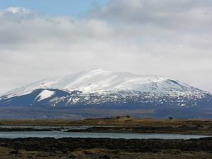
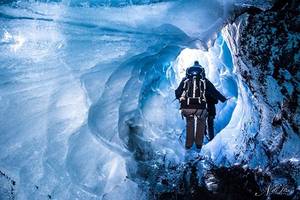
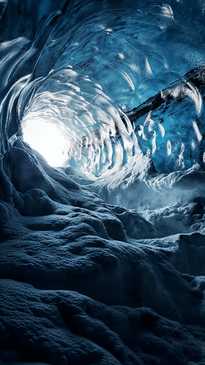
Vatnajökull National Park
Vatnajökull National Park was established in 2008 and includes the entire Vatnajökull glacier and its surrounding vast areas. The southeast includes Skaftafell National Park, and the north has Jökulsárgljúfur. Currently, the national park covers 14% of Iceland's total area, making it the second largest park in Europe. As a general rule, national parks are primarily designated as unique protected areas for natural or cultural heritage, and Vatnajökull National Park is acclaimed for its diverse landscapes formed by rivers, glacial ice, volcanoes, and geothermal activity.